Taking nice photos of soil and buckets
I’m still here doing my landscape archaeology thing. but now we have nice shiny drones to help us out too. I will post some links to some of my photos soon.

Taking nice photos of soil and buckets
I’m still here doing my landscape archaeology thing. but now we have nice shiny drones to help us out too. I will post some links to some of my photos soon.
We’ve set up a dedicated blog for the forthcoming excavations on the longhouses in the Duddon Valley. I will post some more when it is fully up and running. Apologies for the exclamation mark!

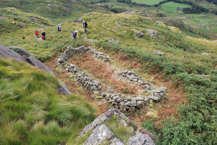
The domestic structure and surrounding walling at Tongue House High Close A
I’ve been lucky to be involved over the last week or so with some preliminary survey work that OA North have been undertaking to assist the Duddon Valley Local History Group (DVLHG) with their ongoing investigations of a series of potentially medieval period longhouse and shieling settlement sites in the upper reaches of the Duddon Valley.
The group have been successful in a Heritage Lottery Fund bid for the Duddon Valley Medieval Longhouse Project to further investigate and then selectively excavate at several of these sites to build upon previous surveys and investigation undertaken between 2011 and 2013, and OA North will be providing professional expertise to assist DVLG in this project over the next few years.
We shall initially be concentrating at three probable domestic sites located in the rough upland pasture intakes on the east side of the Duddon Valley, with two separate examples at Tongue House High Close and one larger enclosure/farmstead with two longhouses at Longhouse Close.

Wintery conditions surveying at Tongue House High Close A
As part of the project I am teaching detailed topographic recording along with helping out with various other strands of preliminary investigation, from UAV drone survey of the wider landscape surrounding the sites through to geophysical and palaeoenvironmental investigation. I will post some more detailed findings as we continue through the project.

UAV survey of trenches at Quay Meadow, Lancaster – 2015 (c) LDHG
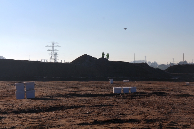
As part of my work at Oxford Archaeology North I’ve recently been practicing (under supervision) flying and surveying with our UAV drones at various archaeological sites in the region. This is in advance of qualifying for a BNUC-S™ pilot qualification to get a Permission for Aerial Work for undertaking commercial projects.
The end of September saw community excavations undertaken at Quay Meadow, in Lancaster. It is located north-west of the Roman fort which is partially extant within Vicarage Fields, and is just below Lancaster Castle. The excavations were undertaken by Lancaster and District Heritage Group in tandem with a wider project aimed at trying to understand the heritage and archaeology of the area which is conducted by Beyond the Castle.

Excavating Roman wall foundations at Quay Meadow – 2015 (c) LDHG

Volunteers from Lancaster and District Heritage Group – Quay Meadow 2015 (c) LDHG
The three excavated trenches were located over interesting anomalies identified in an earlier geophysical survey of Quay Meadow previously undertaken by OANorth. The preliminary results of the excavations suggest evidence for a Roman road heading down towards the original Roman quayside, and what was initially identified as possibly being a post-medieval/modern structure in the geophysics actually turned out to be wall foundations of several Roman buildings found just below the topsoil. There is clearly much much more that Lancaster and District Heritage Group can get their teeth into in future years.

Practicing UAV survey at Quay Meadow, Lancaster – 2015 (c) LDHG
In practice the UAV survey was relatively simple for this site as all we wanted was a general plan view of all of the trenches and detailed post-excavation surveys of each individual trench, which we then created from the photogrammetry in Agisoft PhotoScan. We also created contours of the surrounding topography but this was not as spectacular as earlier results undertaken on the earthworks in Vicarage Fields to the south-east of the site.

Trenches excavated at Quay Meadow, Lancaster – 2015

Roman building foundations in Trench 2 at Quay Meadow, Lancaster – 2015

Tek care!
It’s always nice when I’m back out surveying in the Lake District. I’m out near Cockermouth following a proposed water pipeline route. There’s not too much here but at
least it isn’t raining today.

A bitterly cold surveying day in Bannisdale
Today was mostly spent shivering in the icy wind blowing through Bannisdale in the Lake District. I was instructing volunteers from the Lake District Archaeology Volunteer Network in the dark arts of surveying archaeological earthworks. The site in question was an enclosed hut circle settlement at Lamb Pasture that is scooped into the hillside on the north side of this small relatively isolated Lakeland valley. The site is a scheduled monument and as part of ongoing management and conservation works the Lake District National Park Authority require detailed surveys (which the volunteers will in future undertake) of this and other similar vulnerable sites.

Lamb Pasture enclosed settlement in Bannisdale

Cold cold volunteers

Surveying at Lamb Pasture enclosed settlement in Bannisdale


It’s been a while since I last posted, naughty me! I’m going to be out next week helping with some preliminary work for a community archaeology project in Oswaldtwistle, Lancashire. I will post some more info when we get started.

Cover of the popular publication for the Windermere Reflections Project
The popular publication we produced for the Windermere Reflections project has now come back from the printers. It will shortly be available to purchase directly from the Lake District National Park Authority. Whether you are interested in community archaeology, industrial archaeology or the history of Windermere and the wider Lake District in general it is worth having a look at.
The book concentrates on the surveys and excavation undertaken in the Windermere catchment over the last few years as part of a Heritage Lottery funded project. Themes covered in the publication include metal mines, slate quarries, bloomeries, fulling mills and woodland industries. There is even a picture of me on the back!


